
GIS Art: Where Geographic Data Becomes Art
GIS art transforms geographic information, spatial analysis and digital mapping into artistic expressions of landscape, culture and place.
At GeoArt by Ata Tara, Geographic Information Systems (GIS) are more than tools for producing maps. They provide a creative framework for exploring relationships between people, environments and geography.
Drawing on landscape architecture, geodesign and spatial research, GeoArt combines geographic datasets, cartographic techniques and material experimentation to produce contemporary artworks that communicate spatial narratives through visual and emotional experiences.
The process moves beyond representing geography to interpreting it — transforming spatial information into artistic experiences.
From GIS Analysis to GeoArt: The Creative Process
Geographic analysis as a creative foundation
GeoArt begins with geographic questions, spatial datasets and the analytical methods of Geographic Information Systems (GIS). Rather than using maps simply as visual references, geographic information becomes the foundation of the artistic process.
Spatial layering and interpretation
Through geodesign and cartographic techniques, multiple layers of geographic information are combined, compared and reinterpreted. These layers may represent landscape characteristics, environmental change, cultural identity, historical geography or relationships between people and place.
From digital mapping to material expression
The resulting spatial compositions are transformed into physical artworks through digital printing, laser cutting, resin and mixed-media techniques. Geographic information moves beyond the computer screen into a tangible artistic experience.
Creating an emotional connection with geography
The final artwork invites viewers to engage with geographic information beyond its analytical meaning. Maps become a way to explore memory, identity, belonging and our emotional relationship with landscapes and places.
GIS Art in Practice: Selected GeoArt Works
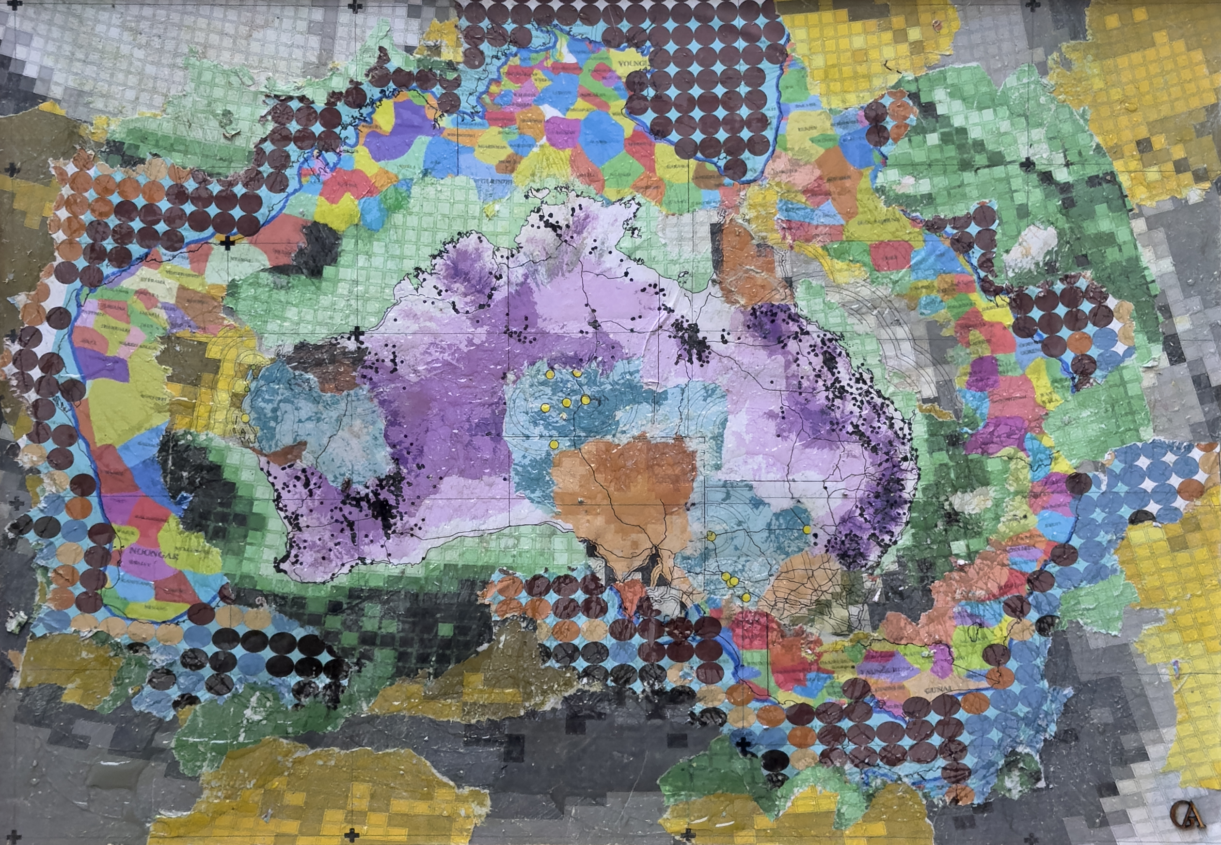
Energy Landscapes in Transition
GIS Art | Energy Transition | Mapping Country
This GeoArt work explores Australia's evolving energy landscape and its enduring cultural connections to Country.Through GIS and spatial layering, datasets representing coal, renewable energy and emerging biofuels are combined with AIATSIS maps of Indigenous Australia. Dense patterns reflect the legacy of extraction, while expanding forms suggest emerging renewable energy futures.
At the centre are the enduring geographies of Country, acknowledging First Nations custodianship and relationships between people, land and energy. The artwork invites reflection on energy transition not simply as a technological challenge, but as an opportunity to shape more responsible futures through care and connection to place.

Geography of Heart
GIS Art | Cartographic Projection | Identity & Belonging
Geography of Heart explores the emotional relationship between people and places through geographic information and cartographic interpretation. Using spatial analysis and the geometry of map projections, the artwork transforms geographic relationships into a heart-shaped composition.
Layered patterns and colours express the connections between landscape, cultural identity and belonging. Geography becomes more than a representation of physical space; it becomes a way of communicating memory, attachment and the places we carry within us.

Redlands Coast
GIS Art | Regional Landscape | Spatial Connectivity
Redlands Coast explores the landscape at a regional scale, connecting Moreton Island, the Brisbane River, North Stradbroke Island (Minjerribah), Redlands and the wider coastal and hinterland systems.Drawing on GIS analysis and regional landscape interpretation, the artworks represent open space, landforms and waterways as interconnected systems rather than isolated sites.
Through layered cuts and negative space, geographic information is transformed into tactile compositions that reveal relationships between landscape, ecology and place. The works invite reflection on regional connectivity, resilience and the long-term stewardship of landscapes.
Beyond Mapping: GeoArt as Spatial Storytelling
GeoArt extends the role of geographic information beyond analysis, planning and visualisation. By transforming spatial data into artistic compositions and physical materials, it creates new ways for people to engage with landscapes, environmental change, cultural identity and place.
Through this process, geographic information becomes more than a technical resource. It becomes a medium for interpretation, reflection and emotional connection.